HMDA Master Plan 2031: The Future of Hyderabad
HMDA Master Plan 2031 has been prepared by HDMA with a vision for development of Hyderabad Metropolitan Region of Telangana. The Hyderabad Metropolitan Development Authority (HMDA) is the planning agency responsible for the development of the Hyderabad Metropolitan Region. The agency was created in 2008 by merging the Hyderabad Urban Development Authority and the Hyderabad Metropolitan Water Supply and Sewerage Board.
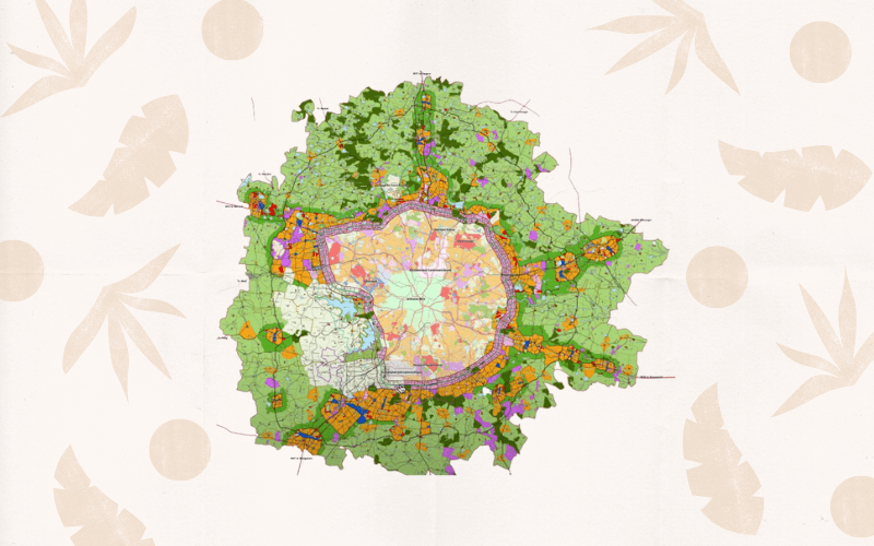
You can download the hyderabad master plan 2031 map from here.
About HMDA
The agency’s primary mandate is to coordinate the development of the region through the preparation of a master plan. The HMDA region covers an area of 7,257 square kilometers and has a population of over 8 million.
The HMDA is responsible for the development of key infrastructure projects in the region, such as the Hyderabad Metro, the Hyderabad International Airport, and the Hyderabad Information Technology Investment Region.
What is HMDA Master Plan 2031?
HMDA has prepared a Master Plan for the city which was released in 2016. The plan envisages the development of Hyderabad as a ‘Global City’ with a focus on economic growth, employment generation, and infrastructure development. The Master Plan provides a comprehensive vision for the development of Hyderabad over the next two decades. It covers a wide range of topics including land use, transportation, housing, environment, and economic development.
The plan is an important document for the future development of Hyderabad and will be used by the government, private sector, and other stakeholders to guide investment and growth in the city.
The HMDA Master Plan comprises four main goals:
1. To ensure the efficient and sustainable development of the Hyderabad Metropolitan Region
2. To promote equitable and inclusive growth in the Hyderabad Metropolitan Region
3. To protect and enhance the environment of the Hyderabad Metropolitan Region
4. To build strong and resilient Metropolitan regions in the region, such as the Hyderabad Metro, the Hyderabad International Airport, and the Hyderabad Information Technology Investment Region.
Areas covered under this plan
Under this master plan, an area of around 5,965 sq km is covered consisting of:
an extended area of 5,018 sq km.
areas covered under the Outer ring Road (ORR) growth corridor.
areas covered by part of the erstwhile HUDA area, outside the ORR growth corridor.
areas covered under the Hyderabad Airport Development Authority (HADA) master plan, outside the ORR growth corridor.
areas covered by the master plan for Bhongir and Sangareddy.
The purpose of the Hyderabad Master Plan 2031 is to accommodate a population of 184 lakhs by 2031 and a workforce of 65 lakhs. The current trends of development are also taken into accounts, such as the Inner Ring Road, Outer Ring Road, and radial roads.
Additionally, promoting, facilitating, and approving HMDA land assemblage and development would be done in any of the following ways, unless and otherwise stated or exempted by the Metropolitan Commissioner:
Land Pooling or Area Development Schemes.
Layout development Schemes
Group Housing Schemes
Group development schemes
Township development
SEZ development
Development Schemes & Special Projects under the HMDA Act,2008
Individual plot sub-division /individual plot or plots Amalgamation
HMDA Zones
The land use zones are strategically divided into 12 under this master plan:
1. Residential zones
Zone 1 – The purpose of this zone is to accommodate residential development in areas that are close to the growth corridor. This zone includes areas that are contiguous to the Corridor, as well as areas that are adjacent to it.
Zone 2 – This zone is comprised of non-contiguous urban areas that have proposed detailed plans for roads and various urban uses.
Zone 3 – The proposed Land Use Plan identifies the remaining urban centers, as well as the areas around them, and classifies them as Residential Land Use Zones. These zones are intended to provide a variety of land uses, such as housing, retail, and office space.
Zone 4 – This zone in the proposed plan includes Gramkantham village and the existing rural built-up area. An additional 300-meter-wide belt outside the Gramkhantam boundary is also included in this zone in order to accommodate the natural expansion of Settlements.
2. Peri-urban use zone – Peri-urban zones are designated areas surrounding residential zones 1 and 2 in the proposed Metropolitan Development Plan.
3. Commercial use zone – The proposed Land Use Plan designates some areas as commercial use zones and commercial strips. These will be beneficial for commercial settlements in the future.
4. Manufacturing use zone – The plan designates these areas as zones for manufacturing use only. No other usage or purpose will be registered or considered.
5. Public and utilities use zone – The proposed plan designates certain areas as public or semi-public facilities and utilities zones. These areas are to be used exclusively for public or semi-public facilities and utilities. Rezoning these areas is not allowed.
6. Multiple-use zone – This area has been zoned for multiple use and transit-oriented development in the proposed plan.
7. Recreation and open space – -The proposed land use plan has designated areas for recreation, parks, playgrounds, and exhibition grounds, as well as open space buffers around the water bodies-use zone.
8. Water bodies – Water body zones generally include rivers, streams, lakes, and tanks. The boundary for these zones has been established by the full tank level / high flood level as indicated on relevant maps. This boundary covers both perennial and non-perennial parts of the water body.
9. Forest zone – All reserved forests will be notified by the Forest department. Unless you have been given specific approval by the department, no activity that is not related to the forest or greenery is allowed in this area.
10. Special reserve zone – Heritage structures, defense / military lands, and bio conservation areas are all found in this zone.
11. Conservation (agriculture) use zone – Conservation (agriculture) zones are the peri-urban areas that have been designated by the government in order to preserve the quality of the soil and land for agricultural purposes. ORR, or Outer Ring Road, serves as the boundary for these types of zones.
12. Traffic and transportation use zone – This area contains all of the major roads that are part of the Metropolitan Development Plan. It is specifically designated for facilities related to transportation, including railways, airports, bus depots, truck terminals and parking lots, logistics hubs, and other uses.
What’s Next?
The Telangana government is in the process of developing a new master plan for the Hyderabad Metropolitan Region. This process includes hiring an international consultancy to help create the Hyderabad master plan 2041. The plan will bring 84 villages that came under GO 111, catchment areas of Himayat Sagar and Osman Sagar reservoirs, under its ambit. With a total area of 7,200 square kilometers, the new master plan will be expansive.
For any further information and clarifications on the HMDA Master Plan 2031.
Also, you can contact us at +91 78160 16598
